|
|
|||
|
|||
|
|
|||
 |
|||
|
|
|||
|
|
|||

|
|||
|
|
|||
Application overview
Operation system: Windows 7/8/10
«GNSS Data Interface» is application that is designed for providing support for «traditional» navigation applications, which are getting GPS/GLONASS data only from serial communication port (COM port). Key features
Full list of application features can be found on the
Features page.
Detailed descriptionApplication is reading navigation data from GNSS Geolocation Sensor (GPS + GLONASS + others, if applicable) and sending data in NMEA format to the serial communication port. In case, if navigation sensor is providing native data in NMEA format, then in navigation application we will get absolutely all info about satellites (visibility, azimuths, signal levels).
In case, if native data in NMEA format are not provided by navigation sensor, then application
is providing emulation of all necessary NMEA data, such as position/elevation/speed and, as well,
is providing «fake» info about satellites (12 satellites).
In case, if signal from satellites or from GNSS sensor will be lost, then application is providing emulation for EMEA data by such way, that navigation application will react like as «GPS signal is lost»). From application menu is possible to run favorite navigation application, by specifying executable file in the settings dialog in advance. And, as well, it is possible to set autostart for navigation application when «GNSS Data Interface» will run. From application menu is possible to open online maps, Google, Yandex, Bing, OpenStreetMap. Online map will open in your default Internet browser with pointer to your actual position on the map. As well it is possible to generate information about your track in GPX, KML (äė˙ Google Earth) file formats. Settings and configuration
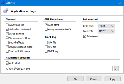
Application settings can be done via correspondent configuration dialog.
In configuration dialog, as well, you can setup automatic or manual startup of GNSS senor, auto opening of specified COM port. In "Expert" configuration this application can provide sending of NMEA data up to four serial communication ports simultaneously. In this way, will be no necessary to use any other software, like GPS Gate, to share navigation information between few navigation applications. Additional information
To setup data link between GNSS Data Interface and your "traditional"
navigation application will be necessary to setup and configure pair of virtual
serial communication ports.
On one side, of this pair, will be "GNSS Data Interface", on other side your navigation software. Windows 10 versions 1909 and 2004Pay attention about bug in privacy settings in Windows 10 versions 1909 and 2004, detailed information you can find in FAQ page.
|
|||
|
|
|||
|
Copyright © 2007 www.black-it.eu All rights reserved. Last modified: 20.12.2022 |
|||
|
|
|||

